|
GR®14A
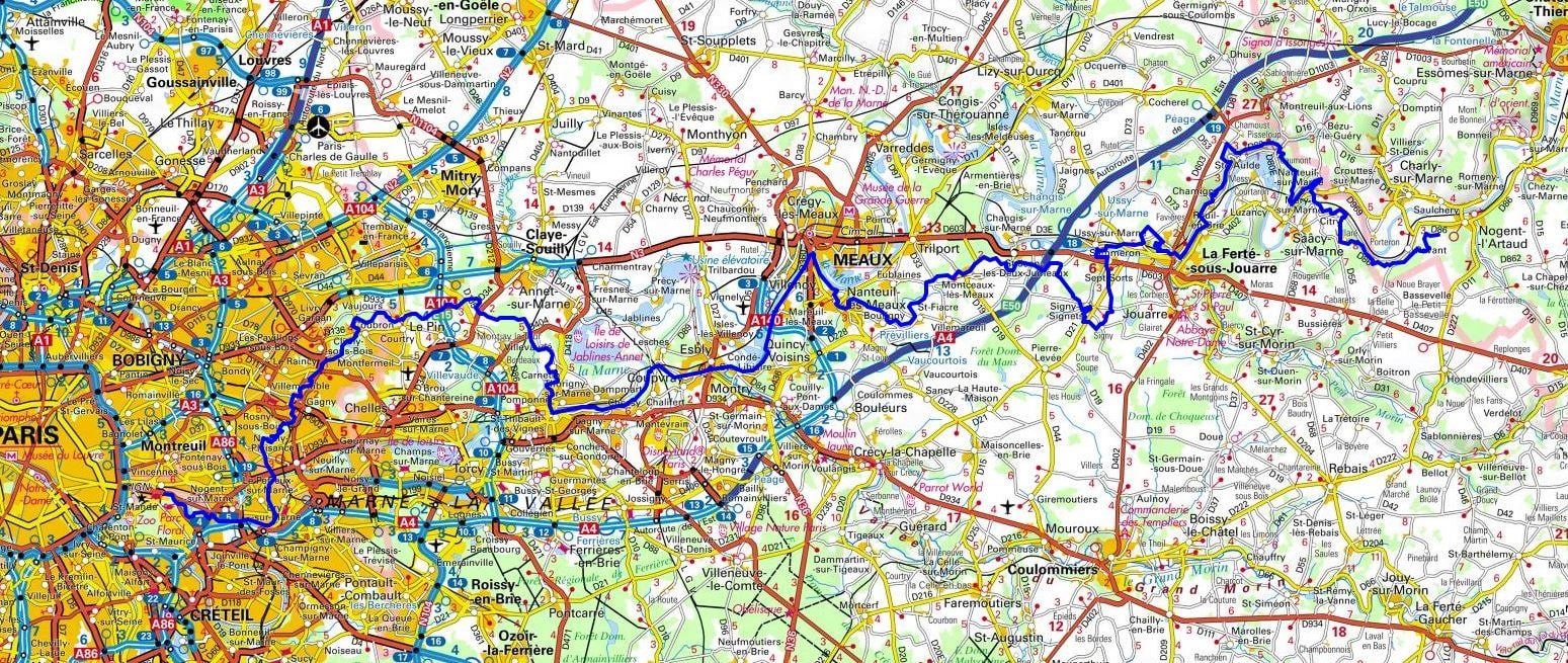
From Vincennes (Val-de-Marne) to Nogent-l'Artaud (Aisne)
|

|
The GR 14A offers a fascinating journey from Île-de-France to the Aisne region, linking the royal history of Vincennes to the rural landscapes of Picardy. The route begins in the wooded Val-de-Marne, following the Marne River through picturesque towns like Nogent, before opening onto the vast fields of Brie and Seine-et-Marne. Historically, the trail connects the Château de Vincennes, a testament to the monarchy, with the riverine history of the mills of La Ferté-sous-Jouarre, marking a profound evolution of the region. The flora is diverse, ranging from the ancient deciduous woodlands of Coubron to agricultural expanses dominated by cereal crops. The fauna is typical of wetlands and farmland: grey herons can be observed along the Marne, and numerous other birds of the plains can be seen before reaching Nogent-l’Artaud.

Google Maps - Google Earth


 Distance: 126km, Elevation maximum: 189m, Elevation minimum: 35m, Elevation gain uphill: 1294m
IGN Maps: 2314OT - PARIS / FORETS DE MEUDON ET DE FAUSSES REPOSES. 2413OT - DAMMARTIN-EN-GOELE. 2414ET - MARNE-LA-VALLEE / FORETS D'ARMAINVILLIERS / FORETS DE FERRIERES ET DE CRECY. 2513OT - MEAUX / VALLEE DE L'OURCQ. 2514SB - MEAUX / CRECY-LA-CHAPELLE / COULOMMIERS. 2613SB - CHATEAU-THIERRY / CHARLY-SUR-MARNE. 2614SB - LA FERTE-GAUCHER / MONTMIRAIL.

Nearby paths:
Crossing of Paris (West-East)
Crossing of Paris (North-South)
Crossing of Paris (West-East-South)
Loop around the Omois (Aisne, Marne, Oise)
Around Ceinture Verte of Ile-de-France
GR®1 Tour of Ile de France
GR®2 Seine River trail
GR®11 Around Ile de France country
GR®14 Ardennes trail
GR®14B From Outines (Marne) to Locheres (Meuse)
GR®75 Around Paris
 It is advisable to follow the beacons all along your hike and to bring you the FFRandonnee topo-guide. You
will also find information on MonGR.fr.
GR®, PR®, GRP®, and the corresponding signs of markings (white / red, yellow and yellow / red) are trademarks of the French
Federation of Hiking. They may not be reproduced without permission. The French Federation of Hiking, state-approved, includes organizations that create and maintain hiking routes on GR®, PR® and
GRP®. It publishes guides these topo hiking routes. With your donations, support the actions of the thousands of volunteer markers of the FFRandonnee.
 GR-Infos.com is an editorial partner of MonGR.fr.

Former holiday hotel with a garden along the Allier, L'Etoile Guest House is located in La Bastide-Puylaurent between Lozere, Ardeche, and the Cevennes in the mountains of Southern France. At the crossroads of GR®7, GR®70 Stevenson Path, GR®72, GR®700 Regordane Way, GR®470 Allier River springs and gorges, GRP® Cevenol, Ardechoise Mountains, Margeride. Numerous loop trails for hiking and one-day biking excursions. Ideal for a relaxing and hiking getaway.
Copyright©gr-infos.com (Authorization for private use only)


